


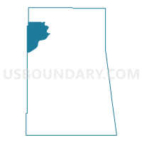
Voting District 1, Delaware County, Oklahoma
About
Outline

Summary
| Unique Area Identifier | 653939 |
| Name | Voting District 1 |
| County | Delaware County |
| State | Oklahoma |
| Area (square miles) | 33.68 |
| Land Area (square miles) | 25.96 |
| Water Area (square miles) | 7.71 |
| % of Land Area | 77.10 |
| % of Water Area | 22.90 |
| Latitude of the Internal Point | 36.56099060 |
| Longtitude of the Internal Point | -94.96174590 |
Maps

Graphs
Select a template below for downloading or customizing gragh for Voting District 1, Delaware County, Oklahoma


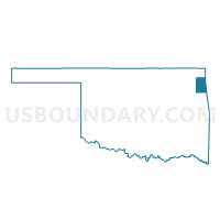
Neighbors
Neighoring Voting District (by Name) Neighboring Voting District on the Map
- Voting District 12, Delaware County, OK
- Voting District 15, Delaware County, OK
- Voting District 2, Delaware County, OK
- Voting District 3, Delaware County, OK
- Voting District 31, Mayes County, OK
- Voting District 710, Craig County, OK
- Voting District 820, Craig County, OK
Top 10 Neighboring County Subdivision (by Population) Neighboring County Subdivision on the Map
- Grove CCD, Delaware County, OK (21,001)
- Jay CCD, Delaware County, OK (9,686)
- Vinita East CCD, Craig County, OK (9,250)
- East Mayes CCD, Mayes County, OK (8,498)
Top 10 Neighboring Place (by Population) Neighboring Place on the Map
Top 10 Neighboring Elementary School District (by Population) Neighboring Elementary School District on the Map
Top 10 Neighboring Unified School District (by Population) Neighboring Unified School District on the Map
- Grove Public Schools, OK (17,261)
- Vinita Public Schools, OK (9,533)
- Jay Public Schools, OK (9,476)
- Ketchum Public Schools, OK (3,884)
Top 10 Neighboring State Legislative District Lower Chamber (by Population) Neighboring State Legislative District Lower Chamber on the Map
Top 10 Neighboring State Legislative District Upper Chamber (by Population) Neighboring State Legislative District Upper Chamber on the Map
- State Senate District 18, OK (78,236)
- State Senate District 1, OK (75,819)
- State Senate District 29, OK (74,057)
Top 10 Neighboring 111th Congressional District (by Population) Neighboring 111th Congressional District on the Map
Top 10 Neighboring Census Tract (by Population) Neighboring Census Tract on the Map
- Census Tract 3759, Delaware County, OK (4,144)
- Census Tract 407, Mayes County, OK (3,924)
- Census Tract 3758.01, Delaware County, OK (3,497)
- Census Tract 3758.02, Delaware County, OK (3,404)
- Census Tract 3735, Craig County, OK (2,348)